


Rando La Ferté Alais

jeanmarcMasson
User GUIDE
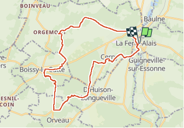

Length
19 km

Max alt
146 m

Uphill gradient
290 m
Km-Effort
23 km

Min alt
52 m

Downhill gradient
290 m
Boucle
Yes
Creation date :
2025-01-22 08:59:25.219
Updated on :
2025-01-22 14:49:16.336
4h29
Difficulty : Very difficult

FREE GPS app for hiking
 SityTrail
IGN / Geographical institutes
SityTrail Plus
The world is yours!
About
Trail Walking of 19 km to be discovered at Ile-de-France, Essonne, La Ferté-Alais. This trail is proposed by jeanmarcMasson.
Positioning
Country:
France
Region :
Ile-de-France
Department/Province :
Essonne
Municipality :
La Ferté-Alais
Location:
Unknown
Start:(Dec)
Start:(UTM)
451958 ; 5370078 (31U) N.
Comments